Showing results 1 to 10 of 104
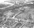
Museum Ref No: B1_0137Aerial view of Longfleet showing Poole Stadium, Henry Harbin School, Wimborne Road and Sterte, 1971
Photograph
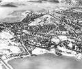
Museum Ref No: B1_0073Aerial view of Longfleet showing Poole Park lake, Seldown, the Stadium, Sterte and Holes Bay, c.1966
Description sent into the website: "I think you will find it is a little earlier than 1966. The Ladies Walking Field is 'intact', but I recall that the 'new' bus station came into use in the summer of 1966 (and no sign of the redevelopment that was to become the Arndale / Dolphin Centre and bus station. The first block of the 'new' hospital looks under construction, but the old Cornelia Hospital is still there - so I would suggest it is earlier in the 1960s - probably 1963 or 1964"
Photograph
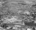
Museum Ref No: B1_0072Aerial view of Longfleet showing Serpentine Road, the George Roundabout, Seldown, the Arndale Centre, railway and gasworks, 1971
Photograph
Museum Ref No: B1_0042Aerial view of Longfleet across the gasworks, railway and Arndale Centre, showing Poole Hospital and Oakdale, 1971
Photograph
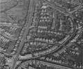
Museum Ref No: B1_0038Aerial view of Longfleet showing the New Inn, Tatnam, Jolliffe Road, Wimborne Road, Fernside Road and Mellstock Road in the 1960s
Photograph
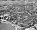
Museum Ref No: B1_0138Aerial view of Longfleet and Parkstone, showing Fernside Road and Wimborne Road, with Oakdale and Holes Bay in the distance
Photograph
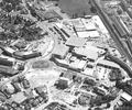
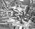
Museum Ref No: B1_0043Aerial view of the Arndale Centre showing part of Longfleet with the George Roundabout, the railway line and Towngate Bridge under construction, 1971
Photograph
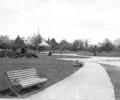
Museum Ref No: B6a_0114View of the bandstand in Poole Park with benches adjacent to the Saltwater lake, houses in the distance.
Photograph
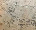
Museum Ref No: VM_XLIV.9_BrownbottomBrownbottom Corner, Fernside Rd at jcn with Parkstone Road.
Detail of Ordnance Survey Dorset Sheet XLIV.9 scale 1:2500 1900 revision with valuation annotations AC
Map