Showing results 51 to 60 of 104
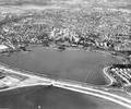
Museum Ref No: B1_0046Aerial view of Longfleet with the railway embankment and Poole Park Lake in the foreground and Sterte and Oakdale in the distance, 1971
Photograph
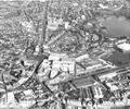
Museum Ref No: B1_0045Aerial view of Longfleet and Seldown showing the George Roundabout, the Arndale Centre, Longfleet Road, the railway line and Towngate Bridge under construction. Poole Hospital and part of Poole Park can be seen in the distance, 1971
Photograph
Website with much information on Longfleet family history
Weblink
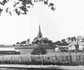
Museum Ref No: C_Longfleet_0005Longfleet Hill from Poole Park showing St Mary's Church
Photograph
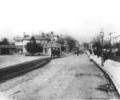
Museum Ref No: C_Longfleet_0003Longfleet Road showing the toll house and junction with Wimborne Road, c. 1890
Photograph
Museum Ref No: C_Longfleet_0006Longfleet; view across field from Parkstone Road; houses; trees on skyline; St Mary's Church
Photograph
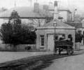
Museum Ref No: C_Longfleet_0004Longfleet Toll House, George Inn, horse and cart
Photograph
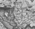
Extract from Isaac Taylor's Map of Dorset, 1760
Map
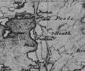
The Tithing of Longfleet. Extract from Christopher and John Greenwood's Map of Dorset, pub 1825-6
Map
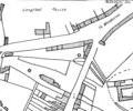
Map showing part of Longfleet in 1841. Extract from a Plan of the Town and County Town of Poole, 1841
Map