Poole History Online is a free online database of photographs, documents and data relating to the local history of the Borough of Poole. This website is managed by Poole Museum and updated by staff and volunteers. Find out more
about this site.
If you experience any problems, please see the
help page.
Showing results 10521 to 10530 of 10844
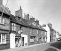
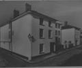
Museum Ref No: D_West_Street_0015West Street, Nos 72-80. Queen Mary Inn and F. Cole (tobacconist). Bracket lamp. Photograph by Barbara Bristowe.
Photograph
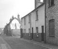
Museum Ref No: D_West_Quay_Road_0012West Street, near junction with Levet's Lane. Marston's Brewery to right.
Photograph
Museum Ref No: D_West_Street_0014West Street, Nos.28-22 (corner with Bay Hog Lane. No.24 was Zollo's lodging house. Photograph by Barbara Bristowe.
Photograph
West Street (Westside) No 32
Description taken from Poole Listed Buildings
Factfile
West Street (westside) Nos 1 To 4
Factfile
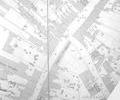
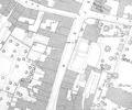
Extract from Ordnance Survey 16.9
Map
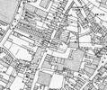
Extract from Ordnance Survey 16.14
Map
Extract from Ordnance Survey XL111.16
Map
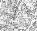
Extract from Borough Engineer's Plan 1952
Map
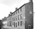
Museum Ref No: E1l_0011West Street at corner with Bay Hog Lane. Jolliffe House.
Photograph