Poole History Online is a free online database of photographs, documents and data relating to the local history of the Borough of Poole. This website is managed by Poole Museum and updated by staff and volunteers. Find out more
about this site.
If you experience any problems, please see the
help page.
Showing results 571 to 580 of 850
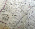
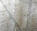
Museum Ref No: VM_XXXV9_PheasanteriesKennelsPheasanteries & Kennels, between Pound Close & Garden Coppice, (Queen Anne Drive).
Detail of Ordnance Survey sheet XXXV.9 scale 1:2500 1900 revision with valuation annotations AC
Map
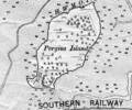
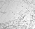
Extract from Ordnance Survey XL1V.10
Map
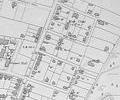
Museum Ref No: rVM-XXXIV.12_PlainfieldFmPlainfield Farm & Darbys Corner. Detail of Ordnance Survey Dorset Sheet XLIII.4, 1:2500 scale, 1900 edition with valuation annotations. AC
Map