Showing results 1 to 10 of 6433
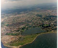
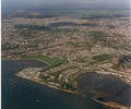
Museum Ref No: K1 19916_10 jpgAerial photo of Poole and Baiter. Copyright holder Kitchenham Photography Ltd. Please refer to copyright holder for commercial use. J.D
Photograph
Museum Ref No: VM_XLIV13_BeehiveInnThe Beehive Inn, Sandbanks Road opp Blake Dene Road, site of Churchil Lodge.
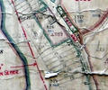
Detail of Ordnance Survey Dorset Sheet XLIV.13 scale 1:2500 1900 revision with valuation annotations AC
Map
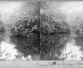
Museum Ref No: AH_Stereocard_Branksome_ChineStereocard reads "Branksome Chine, Bournemouth".
From the Andrew Hawkes collection.
Photograph
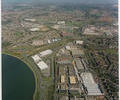
Museum Ref No: K1 9741_6 jpgAerial photograph of Fleetsbridge area. Copyright holder Kitchenham Photography Ltd. Please refer to copyright holder for commercial use. J.D
Photograph
Museum Ref No: K3 191_8 jpgAerial photo of Lilliput (Blue Lagoon and Whitecliff). Copyright holder Kitchenham Photography Ltd. Please refer to copyright holder for commercial use. J.D
Photograph
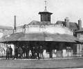
Museum Ref No: BEAM_0001The old fish shambles on Poole Quay. Group of men standing outside.
Early 1900s?
JPBC
Photograph
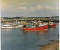
Museum Ref No: K3 5661_4 jpgPhoto of Fishermen's Dock. Copyright holder holder Kitchenham Photography Ltd. Please refer to copyright holder for commercial use. J.D
Photograph
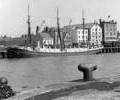
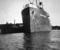
Museum Ref No: F4b_0170"Aar" of Hamburg at Poole Quay, July 1949.
Photograph
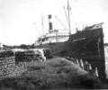
Museum Ref No: F4c_0056"Bengst Sture" unloading timber at West Quay, Poole.
Photograph
Museum Ref No: F4c_0081"Bengt Sture" unloading timber at West Quay, Poole.
Photograph