Showing results 191 to 200 of 571
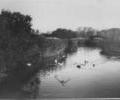
Museum Ref No: B6a_0066Freshwater lake with ducks swimming; houses in distance.
Photograph
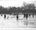
Museum Ref No: B6a_0081Skating on Poole Park Lake, " the big freeze-up " 1963.
Photograph
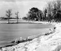
Museum Ref No: B6a_0022The banks of Poole Park Lake under substantial snowfall, looking towards the gasometer.
Photograph
Museum Ref No: B6a_0022The banks 0f Poole Park Lake under substantial snowfall, looking towards gasometer.
Photograph
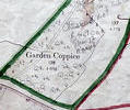
Museum Ref No: VM_XXXV9GardenCoppiceGarden Coppice, jcn of Magna Rd and Merley Lane.
Detail of Ordnance Survey Dorset sheet XXXV.9 scale 1:2500 1900 revision with valuation annotations AC
Map
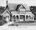
Museum Ref No: AH_Golf_Pavillion_BroadstonePostcard reads "Golf Pavillion, Broadstone".
Printed in Saxony. Dated 29.5.1908.
From the Andrew Hawkes collection.
Photograph
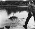
Museum Ref No: B6a_0154Goose having had its leg ringed being released in Poole Park.
From the Ernest Bristowe collection.
Photograph
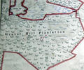
Museum Ref No: VM_XXXV13GravelHillPlantationGravel Hill Plantation, either side of Blackwater Drive
Ordnance Survey Dorset Sheet XXX1V.13 scale 1:2500 1900 revision with valuation annotations AC
Map
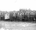
Museum Ref No: B6a_0008Group of people posing on the frozen Poole Park lake.
Photograph
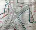
Museum Ref No: rVM_XLIII.11_HamworthyJunction&TurlinMoorHamworthy Junction, Junction Hotel, Bennetts Place, Vineyard Copse, The Grove, Turling Moor House, Yarells Farm, Windmill.
Detail of Ordnance Survey Dorset Sheet XLIII.11, 1:2500 scale,1900 edition with annotations AC
Map