Poole History Online is a free online database of photographs, documents and data relating to the local history of the Borough of Poole. This website is managed by Poole Museum and updated by staff and volunteers. Find out more
about this site.
If you experience any problems, please see the
help page.
Showing results 51 to 60 of 153
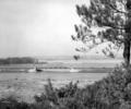
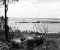
Museum Ref No: Batting/Box 10/Dorset 4/No.1Railway bridge across Holes Bay (Batting photograph)
Photograph
Museum Ref No: Batting/Box 3/Unboxed slides/No.2Steam train approaching Holes Bay bridge. (Batting photograph)
Photograph
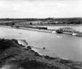
Museum Ref No: Batting/Box 10/Dorset 4/No.2Construction of railway bridge over Holes Bay. (Batting photograph)
Photograph
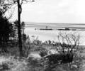
Museum Ref No: Batting/Box 3/Unboxed slides/No.3Construction of railway bridge over Holes Bay. (Batting photograph)
Photograph
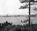
Museum Ref No: Batting/Box 3/Unboxed slides/No.1Construction of railway bridge over Holes Bay. (Batting photograph)
Photograph
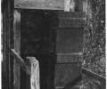
Museum Ref No: AH_Linemans_HutA photograph of a lineman's hut near Corfe Mullen taken in 1968.
From the Andrew Hawkes collection.
Photograph
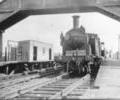
Museum Ref No: AH_Locomotive_Creekmoor_StationA photograph of an LSWR M7 locomotive at Creekmoor Railway Halt, c.1948-1964.
From the Andrew Hawkes collection.
Photograph
Museum Ref No: B1_0052aAerial view of Longfleet showing Towngate Street, Serpentine Road and the railway line
Photograph
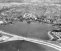
Museum Ref No: B1_0046Aerial view of Longfleet with the railway embankment and Poole Park Lake in the foreground and Sterte and Oakdale in the distance, 1971
Photograph
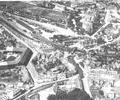
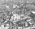
Museum Ref No: B1_0045Aerial view of Longfleet and Seldown showing the George Roundabout, the Arndale Centre, Longfleet Road, the railway line and Towngate Bridge under construction. Poole Hospital and part of Poole Park can be seen in the distance, 1971
Photograph