Poole History Online is a free online database of photographs, documents and data relating to the local history of the Borough of Poole. This website is managed by Poole Museum and updated by staff and volunteers. Find out more
about this site.
If you experience any problems, please see the
help page.
Showing results 1 to 10 of 850
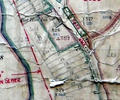
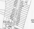
Museum Ref No: VM_XLIV13_BeehiveInnThe Beehive Inn, Sandbanks Road opp Blake Dene Road, site of Churchil Lodge.
Detail of Ordnance Survey Dorset Sheet XLIV.13 scale 1:2500 1900 revision with valuation annotations AC
Map
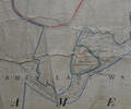
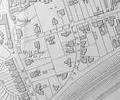
Museum Ref No: VM_XLIV.13_BathingPlaceHospital Island and Bathing Place, west end of Baiter Park nr junction with Furnell Road.
Detail of Ordnance Survey Dorset Sheet XLIV.13 scale 1:2500 1900 revision with valuation annotations AC
Map
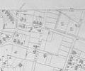
Extract from Ordnance Survey 9.21
Map
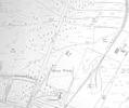
Extract from Ordnance Survey XL1V.9
Map
Extract from Ordnance Survey XL111.16
Map
Extract from Ordnance Survey XL111.16
Map
Extract from Ordnance Survey XL1V.9 1902
Map
Extract from Ordnance Survey XL1V.10
Map
Extract from Ordnance Survey XL1V.10
Map
Extract from Ordnance Survey XL1V.10
Map