Poole History Online is a free online database of photographs, documents and data relating to the local history of the Borough of Poole. This website is managed by Poole Museum and updated by staff and volunteers. Find out more
about this site.
If you experience any problems, please see the
help page.
Showing results 21 to 30 of 850
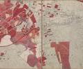
Hamworthy Longfleet and Poole Old Town
Map
Kingston Lacy and Wimborne Minster
Map
Longfleet and Parkstone
Map
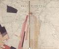
Upton Moor to Canford Heath
Map
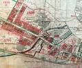
Museum Ref No: rVM_XIII.16_ArchitecturalPotteryArchitectural Pottery, Ultramarine Manufactory. Almshouses, Old Manor House (Rectory), Hamworthy Station
Detail of Ordnance Survey Dorset Sheet XLIII.16 scale 1:2500 1900 revision with valuation annotations. AC
Map
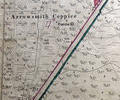
Museum Ref No: VM_XXXV.13_ArrowsmithCoppiceArrowsmith Coppice, between Arrowsmith Rd & Gravel Hill.
Detail of Ordnance Survey Dorset Sheet XXXV.13 scale 1:2500 1900 revision with valuation annotations AC
Map
Extract from Ordnance Survey 12.25
Map
Extract from Ordnance Survey 9.21
Map