Showing results 1 to 10 of 6572
Bourne Steel.
Construction Co ltd.
Structural Steelwork.
St Clements Road, Parkstone.
Phone Parkstone 2768.
Poole Port Guide 1956
Picture
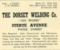
The Dorset Welding Compay. " Lea Works"
Sterte Avenue.
Ship Repairs, Steel Construction and Fabrication, Welding Specialists and Contractors, Manufacturer of Tanks, and Ship and Yacht Fittings, Oxyacetylene cutting and welding on site, Constructional repair work of all types undertaken.
Works Tel. Poole 1623
After Office Hours Poole 1622
& Parkstone 4282.
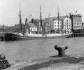
Port of Poole 1950's
Picture
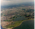
Museum Ref No: K1 19916_10 jpgAerial photo of Poole and Baiter. Copyright holder Kitchenham Photography Ltd. Please refer to copyright holder for commercial use. J.D
Photograph
Museum Ref No: VM_XLIV13_BeehiveInnThe Beehive Inn, Sandbanks Road opp Blake Dene Road, site of Churchil Lodge.
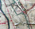
Detail of Ordnance Survey Dorset Sheet XLIV.13 scale 1:2500 1900 revision with valuation annotations AC
Map
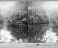
Museum Ref No: AH_Stereocard_Branksome_ChineStereocard reads "Branksome Chine, Bournemouth".
From the Andrew Hawkes collection.
Photograph
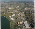
Museum Ref No: K1 9741_6 jpgAerial photograph of Fleetsbridge area. Copyright holder Kitchenham Photography Ltd. Please refer to copyright holder for commercial use. J.D
Photograph
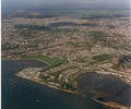
Museum Ref No: K3 191_8 jpgAerial photo of Lilliput (Blue Lagoon and Whitecliff). Copyright holder Kitchenham Photography Ltd. Please refer to copyright holder for commercial use. J.D
Photograph
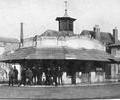
Museum Ref No: BEAM_0001The old fish shambles on Poole Quay. Group of men standing outside.
Early 1900s?
JPBC
Photograph
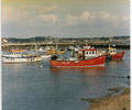
Museum Ref No: K3 5661_4 jpgPhoto of Fishermen's Dock. Copyright holder holder Kitchenham Photography Ltd. Please refer to copyright holder for commercial use. J.D
Photograph
Museum Ref No: F4b_0170"Aar" of Hamburg at Poole Quay, July 1949.
Photograph