Poole History Online is a free online database of photographs, documents and data relating to the local history of the Borough of Poole. This website is managed by Poole Museum and updated by staff and volunteers. Find out more
about this site.
If you experience any problems, please see the
help page.
Showing results 10481 to 10490 of 10844
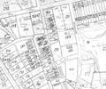
Extract from Ordnance Survey XL111.4
Map
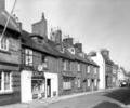
Museum Ref No: D_King_Street_0015West Street: Nos 72-80. Queen Mary Inn to left. F Cole (tobacconist) shop. Bracket lamp. Photographer Barbara Bristowe
Photograph
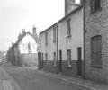
Museum Ref No: D_West_Quay_Road_0012West Street, near junction with Levet's Lane. Marston's Brewery to right.
Photograph
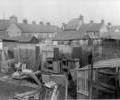
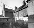
Museum Ref No: D_West_Street_0042West Street, rear of Nos.71-75 from gardens in King Street. Photograph by Barbara Bristowe
Photograph
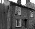
Museum Ref No: D_West_Street_0041West Street, rear of Nos.79-83. Photograph by Barbara Bristowe
Photograph
Museum Ref No: D_West_Street_0040West Street, No.95 (offshoot of West Street). Photograph by Barbara Bristowe
Photograph
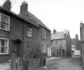
Museum Ref No: D_West_Street_0039West Street, Nos.91-95 (offshoot of West Street). Photograph by Barbara Bristowe
Photograph
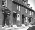
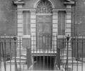
Museum Ref No: D_West_Street_0037West Street, Nos.8-14. Georgian doorways.
Photograph
Museum Ref No: D_West_Street_0036West Street, No.34. Georgian doorway with fanlight.
Photograph
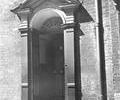
Museum Ref No: D_West_Street_0035West Street, No.8. Georgian doorway with fanlight.
Photograph