Showing results 161 to 170 of 6572
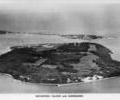
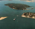
Museum Ref No: AH_Brownsea_Island_with_Sandbanks_behindPostcard entitled "Brownsea Island and Sandbanks". Aero Pictorial Ltd., 136 Regent St., London W1. Copyright Air Photograph. No P2986.
From the Andrew Hawkes collection. For commercial use please contact the copyright holder
Photograph
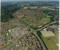
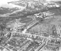
Museum Ref No: K1 9164_13jpgAerial photo of Canford Heath.Copyright holder Kitchenham Photography Ltd. Please refer to copyright holder for commercial use. J.D
Photograph
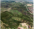
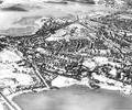
Museum Ref No: K4 9467_11 jpgAerial photo of Canford Heath. Copyright holder Kitchenham Photography Ltd. Please refer to copyright holder for commercial use. J.D
Photograph
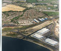
Museum Ref No: K2 3836_1 jpgAerial photo of Creekmoor as seen from Holes Bay. Copyright holder Kitchenham Photography Ltd. Please refer to copyright holder for commercial use. J.D
Photograph
Museum Ref No: AH_Ferry_leaving_Poole_HarbourPostcard of a ferry leaving Poole Harbour with Brownsea Island in the background.
Produced by S.Sieger. Copyright I.P.S. 1984.
From the Andrew Hawkes collection. For commercial use please contact the copyright holder.
Photograph
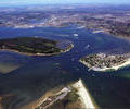
Museum Ref No: AH_Poole HarbourPostcard of Brownsea from the air. Beyond Shell Bay, Sandbanks Peninsula and the chain ferry lay Poole Harbour, Brownsea island, Lilliput, Poole Quay and the town.
Published by Sieger and Felpool cards. Copyright S. Sieger.
From the Andrew Hawkes collection. For commercial use please contact the copyright holder.
Photograph
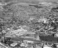
Museum Ref No: B1_0137Aerial view of Longfleet showing Poole Stadium, Henry Harbin School, Wimborne Road and Sterte, 1971
Photograph
Museum Ref No: B1_0073Aerial view of Longfleet showing Poole Park lake, Seldown, the Stadium, Sterte and Holes Bay, c.1966
Description sent into the website: "I think you will find it is a little earlier than 1966. The Ladies Walking Field is 'intact', but I recall that the 'new' bus station came into use in the summer of 1966 (and no sign of the redevelopment that was to become the Arndale / Dolphin Centre and bus station. The first block of the 'new' hospital looks under construction, but the old Cornelia Hospital is still there - so I would suggest it is earlier in the 1960s - probably 1963 or 1964"
Photograph
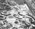
Museum Ref No: B1_0072Aerial view of Longfleet showing Serpentine Road, the George Roundabout, Seldown, the Arndale Centre, railway and gasworks, 1971
Photograph
Museum Ref No: B1_0042Aerial view of Longfleet across the gasworks, railway and Arndale Centre, showing Poole Hospital and Oakdale, 1971
Photograph